Moosehead Lake Region offering new trails, outdoor adventures and challenges
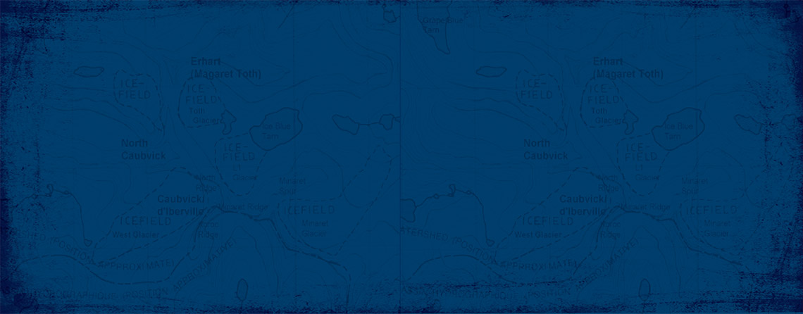
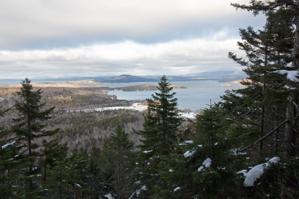
by Aislinn Sarnacki / Bangor Daily News The community in the Moosehead Lake Region is banding together to showcase the area’s many natural resources and make outdoor recreation more accessible to visitors. A number of collaborative projects are underway, bringing together area businesses, organizations and state agencies in an effort to improve area signage, mapping, trails and other outdoor resources for the public. “I see an arrow pointing in the positive direction for the whole region in terms of people both locally and from away getting excited about the natural resources and understanding how much there really is to explore there,” said Rex Turner, outdoor recreation planner for the Maine Bureau of Parks and Lands. New trails taking shape In 2014, the Maine Bureau of Parks and Lands announced that construction had begun on an expanded network of trails in the Moosehead Lake Region. Three years later, this project has come a long way. Two new trails have been completed: a 3.25-mile trail that leads up and over Number Four Mountain and a 3.7-mile trail leading to Eagle Rock, a stunning outlook on the northwest peak of Big Moose Mountain. In addition, the Maine Bureau of Parks and Lands has constructed two new portages on Moose River that allow paddlers to avoid whitewater sections of the river between Long Pond and Little Brassua Lake, a route that is a part of the Northern Forest Canoe Trail. “We’ve got a lot of work ahead of us still, during the next couple of seasons,” Turner said, “but we’re making some good progress.” This spring, the project will move forward as Maine Conservation Corps crews extend the Number Four Mountain Trail southward, with plans to construct a trail all the way to the summit of Baker Mountain at 3,521 feet above sea level. Also scheduled for this spring is the completion of the new 6-mile Blue Ridge Hike & Bike Trail, which is located north of the Katahdin Iron Works Road, east of Greenville. Highlights of the western portion of this trail include Rum, Cranberry and Notch Ponds, which will provide remote camping and fishing opportunities. And further to the east, trail users will be rewarded with views of surrounding mountains. Summer trailheads are planned for near Rum Pond, next to Vaughn Stream as it crosses the Katahdin Iron Works Road, and near Hedgehog Pond off the Katahdin Iron Works Road. This regional nonmotorized trail development is a collaborative project between the Maine Bureau of Parks and Lands and Weyerhaeuser Co. (which recently merged with Plum Creek), and several partners including the Maine Conservation Corps, Appalachian Mountain Club, Northern Forest Canoe Trail and the newly formed Moosehead Trails, a group with the mission of helping maintain walking, hiking and biking trails in the greater Moosehead Lake region. “Moosehead Trails is really focused not just on these trails but regionally as a stewardship volunteer group,” Turner said. “It’s been getting organized for a season or two, and last year, they started doing some events and offering trail volunteer opportunities.” A challenge for all seasons Among the new offerings in the Moosehead Lake Region is the Moosehead Pinnacle Pursuit, a hiking challenge that features six celebrated peaks in the region: Eagle Rock, Mount Kineo, Big Moose Mountain, White Cap Mountain, Borestone Mountain and Number Four Mountain. Launched last summer, the challenge is to hike all six peaks. “Most of them I didn’t even know about,” said Bradley Randall, who completed the challenge last summer with his girlfriend, Marianne Ferguson. They were both living in Orono at the time, and they learned about the challenge through social media. “For me, I’m just a really competitive person, so if you put a list in front of me, I just want to check it off and accomplish something,” said Ferguson. To participate in the challenge, both filled out an application, available at mooseheadpinnaclepursuit.com, and recorded the date of each hike, including the time they reached each peak. Once completed, they sent the application, along with a $10 entry fee, to the Moosehead Chamber of Commerce. In return, they received confirmation letters, an official Moosehead Pinnacle Pursuit badge and sticker, and their names were placed on the Moosehead Pinnacle Pursuit online registry. “I have the sticker on my car,” Ferguson said. “And I’m putting the patch on my bag.” “For the first year, the response has been really positive,” said Dan Rinard, operations manager for Appalachian Mountain Club’s Maine Woods Initiative and one of the organizers of the Moosehead Pinnacle Pursuit. “At [Appalachian Mountain Club], a number of our guests have been doing it and are really excited about it, and I’ve heard through the [Moosehead Chamber of Commerce] and other local groups in Greenville that a lot of folks are doing it, a mixture of folks that live in the area and people who are coming from away. I’ve heard a number of stories about people who have extended their stay to do the whole thing on their visit.” For those looking for an additional challenge, there are three additional Moosehead Pinnacle Pursuit badges to collect. The Winter Moosehead Pinnacle Pursuit badge is awarded for completing the challenge in the winter (Jan. 1 through April 15); the Ultra Moosehead Pinnacle Pursuit badge is awarded for completing the challenge within a continuous 48-hour period; and the Winter Ultra Moosehead Pinnacle Pursuit badge will be awarded for completing the challenge within a continuous 48-hour period in the winter. Both Randall and Ferguson said that you don’t have to be an expert hiker to attempt the challenge in the summer, but that the winter and ultra badges require more experience and planning. “As long as you’re taking one hike at a time, I think it’s a good way to get out there,” said Ferguson. “You can work up to it and start with the easy ones.” She considers Whitecap Mountain to be the most difficult peak in the challenge, and Borestone Mountain and Mount Kineo the easiest. Finding your way Sometimes the hardest part of an outdoor adventure in Maine is simply finding it, especially when traveling unmarked woods roads in places such as the Moosehead Lake Region. Recognizing this problem, volunteers from the community have been working for more than a year on the Moosehead Lake Wayfinding Project, a plan to design and place attractive and clear signs in places throughout the region that will help visitors find their way to public attractions, such as hiking trailheads, boat launches, visitor information centers, public parking and motorized trailheads. Another goal of the wayfinding project is to reduce the clutter of existing signs by consolidating them and by ensuring that signs are in good condition and provide necessary information. “The wayfinding signs improves the visitor experience and results in an economic benefit when visitors stay longer and make return visits, because they perceive that there are more attractions for them to enjoy,” said a leading volunteer in the project, Sally Johnson, in a recent press release. The first phase of the project includes the southern half of Moosehead Lake, from Rockwood and Kokadjo to Greenville. The northern half of the lake will be in the next phases, as public access and road condition issues are resolved. Future plans are to complement the signage with an online mapping function on the Moosehead Lake Economic Development Corporation website. This map will match the kiosk information map, and it will enable smartphone access for Wayfinding to the destination points as well as to area businesses. Project donors include Elmina B. Sewall Foundation, Piscataquis County and the state of Maine, as well as for the expertise of the consulting group Axia Creative. More Moosehead adventures Though new trails, signs and visitor resources are in store for Moosehead Lake Region, the area has been home to a wealth of outdoor venues for years. On the southeast shore of Moosehead Lake, Lily Bay State Park continues to be a prime location for families, hikers, paddlers and campers to enjoy the quiet woods and scenic lake, which at 74,890 acres is the largest lake in Maine. Established in 1961, the state park covers 925 acres and features a network of campsites, trails and boat launches. On the other side of the lake, Little Moose Public Reserved Land unit covers more than 15,000 acres and offers a more remote hiking and camping experience on the impressive ridges of Little and Big Moose mountains. Back to the west side of the lake, the Appalachian Trail runs through the 100-Mile-Wilderness; hikers flock to Gulf Hagas, a dramatic slate gorge featuring scenic waterfalls and swimming holes; and the Appalachian Mountain Club runs a 130-mile network of multi-use trails connecting three “off-the-grid” wilderness lodges. “[Appalachian Mountain Club] has been working on improving our trail system for a number of years now,” said Rinard. “One of the things we’ve been working really hard on is upgrading our ski trail networks so that they’re mountain bike friendly in the summertime. I think after this trail work season this summer, we’ll be doing a really big push for mountain biking.” For those adventurous enough to navigate the maze of gravel logging roads, public hiking trails climb Indian, Chairback, Third and Little Kineo mountains. For history buffs looking for an easy trek, there’s a historic B-52 crash site on Elephant Mountain, accessible by a short footpath. And for the ambitious, there are the steep, remote slopes of Little Spencer and Big Spencer mountains. There’s an outdoor adventure for everybody in the Maine woods, and the Moosehead community is working hard to spread the word. http://bangordailynews.com/2017/02/17/outdoors/moosehead-lake-region-offering-new-trails-outdoor-adventures-and-challenges/ printed on February 21, 2017